Rew Down Local Nature Reserve
Rew Down is beautiful chalk grassland. There are always wonderful views down to the coast, as far as the downs above Niton to the west and over to St Boniface Down in the east. Rew Down played a very important part in the defence of the realm in the Second World War. The blast wall and base of the ‘Y’ station is now all that remains, but sitting by it and surveying the coast, you will understand why it was so strategically important.
If you are walking over the site with your dog, please keep it under control and do not allow it to worry the grazing animals.
What to look and listen for…
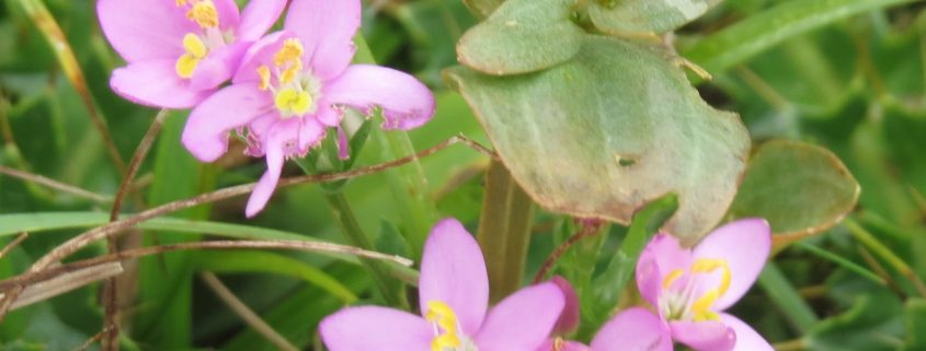
From the top of Rew Down you have the most wonderful views. In early spring look out for the dog violets and later bluebells form a carpet under the ash trees, and cowslips cover the lower part of the slopes – fairies are said to hide under the flowers, but its name actually means ‘cow-slop’ or cowpat as it is common in pastures. The early gentian is found here and usually flowers during May and June, it is a small, rare annual or biennial wildflower. It grows on chalk grassland, favouring south-facing slopes with thin soil that are grazed to keep the vegetation cover low. Its purple, trumpet-shaped flowers appear in branching clusters. Pyramidal orchids make a fine show in late June and early July and stemless thistles, with their deep purple flower heads and sharp shiny leaf rosettes flat against the ground, are a feature of late summer. Butterflies love Rew Down’s flowers. The adonis blue butterfly has been seen at Rew Down; it is the most striking of the blue butterflies. It was once on the endangered species list but it is now making a good recovery thanks to favourable management of the species rich chalk downland habitat it needs to survive.
At the bottom of the Down, you will hear lots of garden birds such as robin, wren, blue tit, great tit, dunnock and goldfinch. Listen to the rooks from the rookery. You will also hear jackdaws and carrion crows. Sit near the scrub and listen for the distinctive call, ‘a little bit of bread and no cheese’, which will tell you that a yellow hammer is nearby. Whitethroats also like the scrub.
… and smell and touch
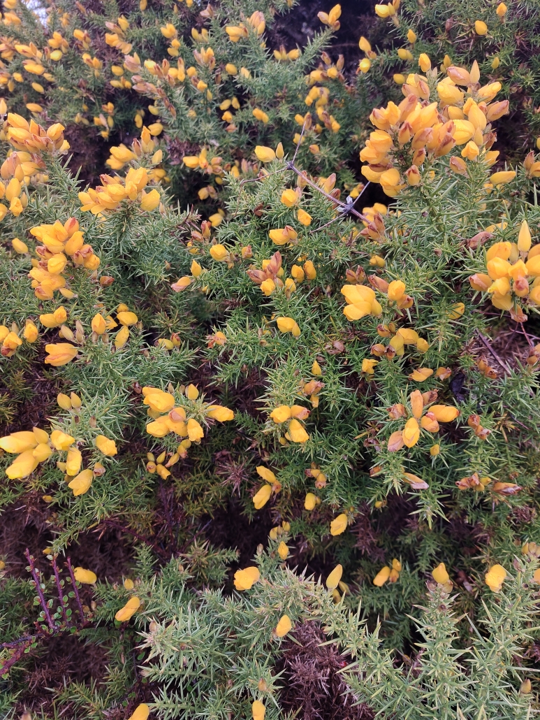
The gorse has a coconutty smell. In late spring sniff the bluebells. If you can smell them, they will be English ones. Stinking iris loves the wetter environment alongside the bottom of the slope; it smells like roast beef.
Make a daisy chain. In the past they were used to link young lovers, not to mention the generations of girls who have long pulled off the petals one by one, chanting ‘he loves me, he loves me not’ or tell the time with a dandelion clock.
Our brilliant friends – the Botany Group from the Isle of Wight Natural History Society visited Rew Down in May 2017 and have produced a list of all the flora they spotted.
Ventnor’s Y station
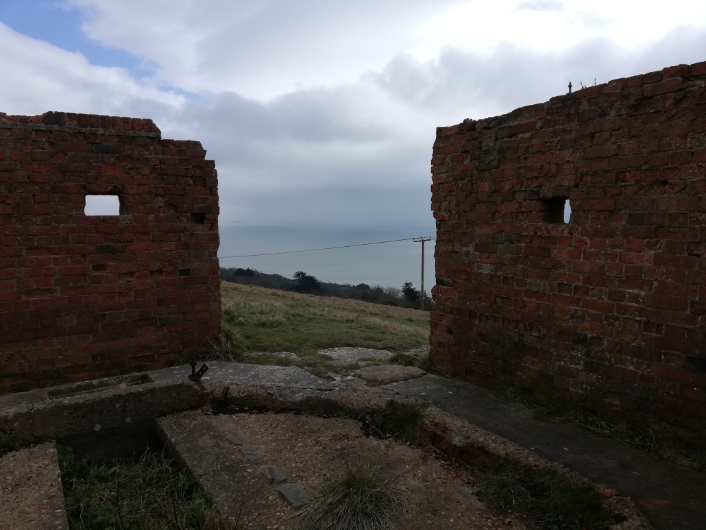
Ventnor was home to a secret system that was critical to the Allied victory. It was the site – the only one on the island — of one of the twenty or so Royal Navy ‘Y stations’ (from ‘WI’ for Wireless Interception) that intercepted and located enemy transmissions and passed the information on to Portsmouth HQ and Bletchley Park (‘Station X’) for decoding. The headquarters of the Ventnor Y Station was ‘The Heights’ on Whitwell Road. Manned by Wrens from the WRNS Special Duties (SD) Service, it mostly intercepted messages in the German Naval Enigma code, which was broken by Bletchley Park. Reading these messages was critical for winning the Battle of the Atlantic against the U-boats.
As important as intercepting the messages was, knowing where they came from was equally valuable. Some Y Stations, such as Ventnor, had DF (Direction Finding) facilities, usually a 30-foot wooden tower on a concrete base, incorporating a hut with a swivelling antenna. If two or more stations could get a bearing on an enemy transmissions, the sending ship could be precisely located. A skilled operator could pin down the location in as little as six seconds. The Ventnor tower stood on Rew Down and most such towers were manned by a single person.
On 15 July 1944 the tower was damaged by a V1 ‘doodlebug’ flying bomb and a large crater about 100 feet from the site of the tower is still visible. The Y station wasn’t the target, it was sheer bad luck. Although repaired, the Ventnor Y station ceased operation by September 1944, presumably because Allies now controlled the parts of France and the Channel it monitored. The tower remained standing until 1948 or 1949, but all that now remains is an octagonal brick ‘pillbox’ with a concrete foundation and external concrete pads for the wooden supports. Despite this it is one of the best preserved Y station towers nationally and possibly only one of two that retain their brick blast wall.
The above information has been kindly provided by Ventnor and District Local History Society and the Isle of Wight Industrial Archaeology Society and more information can be found on these two sheets.
Listening to the Enemy – Ventnor’s ‘Y’ Station
Listening to the Enemy – The Wrens’ War in Ventnor
Photos and technical details can be found here
Nature at home and activities on site
We have produced a super Colouring Sheet for you to download and complete at home. We have also produced an I Spy Sheet and Map for you to print at home, or download to your phone and take to the site. And become a Bug Bunch Ranger. All these activities and resources can be found here.
Managing the site
The site has a history of grazing and cattle have been on the site at times since January 2003, helping to keep down the faster growing grasses that would overwhelm the more delicate chalk plants. The site is in a Countryside Stewardship Scheme which means we manage it with advice from Natural England. Therefore the grass is not cut until mid July, allowing the flowers to set seed.
How to get there
Rew Down is to the west of Ventnor Town. There is one entrance to the top of the site on Steephill Down Road where parking is easiest and there are three entrances to the bottom of the site, all footpaths from Whitwell Road.
On foot and by bike – Access from the surrounding countryside is good. Footpaths V54, V54a, V64, V64a all transit the site, V56 skirts the west border. There is an entrance on Steephill Down Road, and three entrances from Whitwell Road.
By bus – For the top of the site: Steephill Down Road stop (Route 3) is 30 metres from Steephill Down Road then access the site up the hill along Steephill Down Road behind the chip shop, as described above. For the bottom of the site: Pine Point Bus Stop (Route 6 and Island Coaster, which is seasonal). Walk west where you will find three entrances. There is no pavement and cars drive fast along this road. (Bus Timetables)
By Car – For the top of the site: Steephill Down Road is accessed from Newport Road. Follow the brown sign marked ‘Ventnor Golf Club’. After approximately 100 metres the asphalt road turns to a rougher track. You need to park roadside before this point. There are usually on-road parking spaces available. Code for SATNAV PO38 1AE. For the bottom of the site: park in unrestricted areas on Whitwell Road and enter through one of the three unmarked paths. Note that whilst there are unrestricted parking areas on this road, it is a fast road and parking can be hazardous.
what3words for Steephill Down Road entrance ///trophy.scared.lamenting
Access
There is approximately an altitude difference of 50 metres between the top and bottom of the site, which is about a slope of 1 in 5. In other words, this is a steep site. It is not suitable for wheelchairs, buggies or anyone with mobility issues.
There is an entrance from Steephill Down Road. There is an Information Pillar at this point. The site Information Pillar has a QR code that links to an audible description creating a mind’s eye view of the area to allow a visually impaired person to enter with confidence. The information pillar also has a QR code that links to a map and activities. There is also a site map on the Information Pillar.
The paths are grass or earth and very narrow. They can be slippery at all times of year. The site is popular with rabbits so care should be taken around rabbit holes. The site is occasionally grazed so dogs should be kept on leads at these times. Because we are managing the grassland for its flora, the meadow is not cut until mid July. This can mean that the paths are difficult to find in early summer.
There are no public toilets near this site. The nearest are in the town of Ventnor.
We have written an Access Statement for this site. This includes mobility and sensory issues and opportunities. We welcome feedback from users.
We have produced an audible description creating a mind’s eye view of the area to allow a visually impaired person to enter with confidence. It will describe the entrance, the size of the area, where to find further information or help and any major obstacles or features. Information has been produced by visually impaired people ensuring it is useful and accurate. Access the description by scanning the QR code to the left of this text on your phone or tablet, or by clicking here.
Get Involved
There are various ways you can help improve and maintain our sites. We rely on volunteers to help with many tasks on our sites and also need people who are happy to regularly visit the site and be our “eyes and ears”, this means we can respond much quicker to issues. Or, maybe you would like to help us with events. Find out more here.
You can also help by becoming one of our regular supporters. Even giving a few pounds each month can make a real difference, with your donation being invested into site management and improvement work to benefit site visitors and look after our precious wildlife. Sign up here.
